Teton Sheep Voluntary Ski Closures

Sheep Tracks on Doane Peak. March 2017. Jediah Porter photo.
Summary:
Voluntarily avoid skiing, from December 1 through March 31, the terrain marked in red on these maps.
Background:
We have been talking about Teton Bighorn Sheep and ski access. There are a plethora of resources and discussions going out there. Peruse the links to come up to speed.
Hadley Hammer Wildsnow Op-Ed (and great ensuing discussion in the comments)
Proposal:
In my WildSnow opinion piece I propose that we voluntarily avoid the areas recommended for closure. There seems to be some interest in that. Further, there is enough information out there for any skier now to make their own choices for as long as such a choice is voluntary. However, I made this page to better summarize what and when we should change our ski terrain choices. Nothing on this page is unique. It is simply a summary of information already available elsewhere. This page and associated map(s) will surely change as we all better understand what is needed and desired.
One major thing that has been missing is a cartographic summary of the recommended closures. And a discussion of exactly what is at stake here. I’ve done some organization and investigation. To be clear, the below is my interpretation of the terrain and skier use patterns. I likely understand both wildlife management and backcountry skiing better than most, but I’m not perfect. Further, the Working Group’s maps and documentation is somewhat vague in some important cases, perhaps by design. (Very important note; the working group’s recommendations are not closures. Closures are enacted by the land managers. Or, as is my hope, by us, voluntarily).
I’ve pored over the working group recommendations and cross-referenced it with my own Teton ski patterns and knowledge. I’ve also compared it to existing ski tick lists and catalogs. Let us confine the discussion to what the working group calls “Quadrant 1” terrain closures. This is terrain that they concluded is high value to sheep and low value to skiers, relatively speaking. Their terminology is slightly different and they take into account some other feasibility criteria. But that’s basically what it boils down to. Of course, as ski standards increase we can get to more and more terrain and the value changes. Value to skiers is subjective. Nonetheless, the valuation of ski terrain in a process like this is unprecedented and unique.
Dates:
Let’s talk closure dates. The working group mentions “winter closures” with no mention of specific dates. Current Grand Teton National Park closure baseline dates are December 1 to March 31. This is flexible. In 2019 (a big snow year), for instance, the closure was extended to April 30. The web has various references to the closures and dates, including a TetonAT article that mentions December 15 as the start of closure. In any case, if we wish to voluntarily avoid this terrain, it seems that going with the baseline dates of December 1 to March 31 is appropriate.

Sheep. Static Peak. April 2018 Jediah Porter photo
What is at stake, in terms of Teton ski tick lists?
TetonAT.com is a pretty authoritative resource for modern Teton skiing. The late Steve Romeo was an energetic skier and equally disciplined with cataloging what he did. He didn’t catalog every ski day of his, but he cataloged more than most do. By his own admission on the site, he is more apt to document the further, wilder excursions than the more routine ski days closer to the road. I went through his trip reports (296 of them that cover the Tetons) and found 7 that he couldn’t do if the quadrant 1 closures are enacted. This takes into account both terrain and date. Steve reports on some ski descents of terrain that would be closed, but skied them outside the closure window.
Of the three Teton lines in the “Fifty Classic Ski Descents of North America” book, none are affected by proposed closures.
Mark Smiley’s (a firm opponent to permanent ski closures in the National Park and a great friend of mine) digital ski atlas references 47 select ski lines. None of them would be affected by these closures.
Kim Havell’s Teton skiing resume is sometimes cited as a high-level, all-around ski mountaineer’s “tick list”. Of the 93ish ski lines mentioned on her website, 1 of them would be off limits. (her list mentions Hunt and Static peaks that are under current closures. She skied them during the open season)
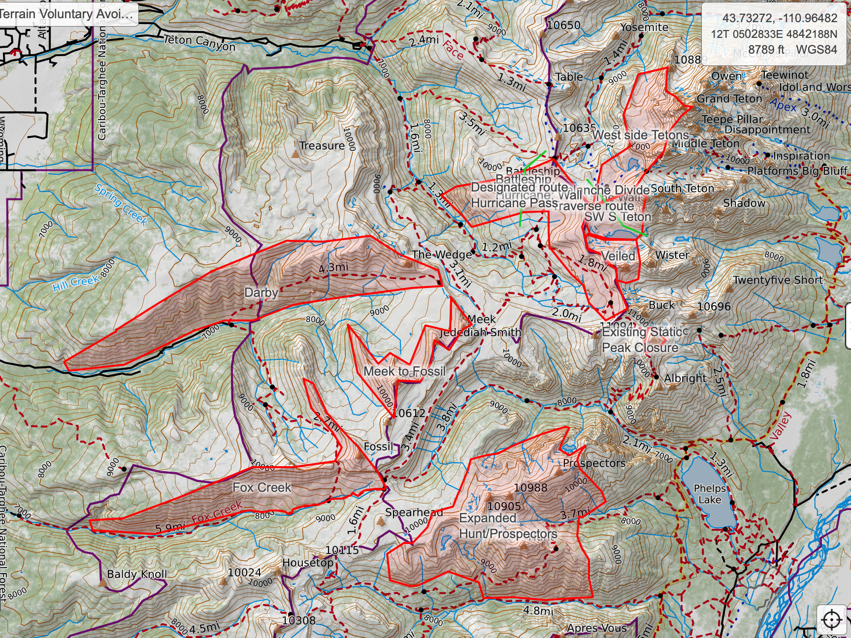
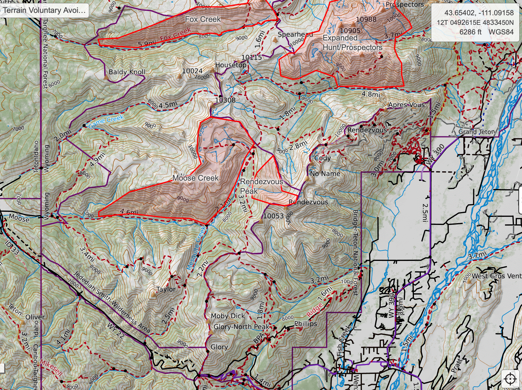
Map:
This map shows the proposed quadrant 1 closures. (Same as linked above) I made this map. This is one person’s interpretation of the imagery and descriptions available in the working group report. Map images also below. Linked map is higher res and more interactive. Images here are screenshots from the same map. Linked map is likely to change and clarify while images might be slower to get updated.

Questions/Clarifications:
Finally, some further and ongoing questions for the working group, skiers, and sheep biologists. In some places and situations, the approximated Working Group closure maps are vague and/or questionable. This is by no means a comprehensive list of questions/clarifications/suggestions. It is my hope that we can resolve these in an informal matter. But I also hope that, if this goes to an official closure process, these questions and terrain nuances will be addressed.
Grand Teton Owen-Spaulding Route. The Dartmouth Basin closure image suggests that everything “west facing” on the Grand Teton should be closed. In enforcement etc. it would be easy to draw the line along a watershed boundary. If this were done, important parts of the Owen Spaulding route would be off limits. Moving the line just a hundred feet west/north for a few hundred feet of boundary distance would allow the important OS route to remain accessible.
Top-down access to Black Hole Couloir. It appears that the line was drawn to keep Black Hole Couloir access open. This is great. However, there is an ascent route to the back of the Black Hole Couloir notch that is safer, faster, and easier than going up and back down the Black Hole itself. A designated route to allow top down access to the Black Hole would be 1600 feet long. Or the closure could be reduced by about 42 acres to allow this access.
I hope that someone with greater familiarity with the skiing accessed from JHMR can chime in and point out any obvious issues with the quadrant 1 closures.
What is the timeline for this? What are the criteria by which we might choose to revisit this terrain during these times? It seems that it could go either direction with either potential direction of the sheep population. The sheep could get better, and we get to go back to these places. The sheep could get worse, and we get to go back to these places. How do we conclude this experiment and choice?
Conclusion:
I would like for this to be a “living document”. I don’t mind one bit if it ends up being passed off/hosted in a more appropriate location. I’m happy to continue to expand and maintain this resource, or to hand it off to someone more qualified.
Yes, there is a great deal more terrain mentioned in the working group paper. For now, let’s focus, with that working group, on the highest priority, lowest impact terrain to avoid.